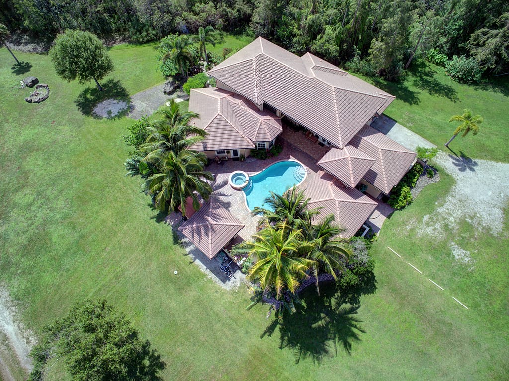
You know that professional real estate photography is a must for your listing. But what about real estate drone photography? Is the extra expense really worth it? That depends on the property. In many cases, the answer is an emphatic ‘Yes!’.
Why drone photography?
Aerial photos showcase the features of large estate type properties, waterfront, vacant land, and commercial properties like strip malls and car dealerships. But what about smaller, more conventional properties? In this group of properties, drone photography highlights features like pools, nice yards, great neighborhoods, and access to nearby amenities like parks and shopping.
Aerial views can be quite eye-catching, so including them will make your listing stand out and generate more views. In one study, 83% of prospective sellers said they would be more likely to list with an agent who regularly uses drone photography. High volume agents, those in the top 25% in sales volume, are 3.5 times more likely to use aerials than agents in the bottom 25% of sales volume.
In reality, most properties will benefit from aerial views. A phototgrapher who is well experienced in drone photography can advise you on whether to include aerials for a particular property.
Now that we’ve established that real estate drone photographs are a good investment for most listings, let’s take a look at how they’re done and how you can get them.
What is a drone?
A drone is one component of what is known in more technical jargon as a small Unmanned Aerial System, or sUAS. A drone is the aircraft in the system, usually a helicopter type, or ‘rotary wing’. The most common configuration is a quadcopter, with four propellers, but other configurations with six propellers (hexacopter) or even eight propellers (octocopter) are not uncommon, especially in more technical applications like construction and inspection work. There are also fixed wing drones that look like small airplanes. These are used in applications like agriculture, where the necessity of covering a large area makes flight distance and duration more important than maneuverability.

Another component of the sUAS is a remote control device to control the flight of the drone. The remote exchanges information with the drone, sending flight and camera control instructions and receiving telemetry – the drone’s position, altitude, heading, speed, battery condition, etc. This information is usually displayed on an attached tablet or cell phone, along with a view of what the camera is seeing at that moment. The remote is the only other component that we need for real estate drone photography. A more complex sUAS may use other components like ground control stations and ground control points, but those are unnecessary if all we need to do is capture aerial real estate photos and video.
For great drone pictures and video we obviously need a good camera. Drones are limited in the amount of weight they can carry aloft, so cameras that are designed to be lightweight and remote controllable are needed. Some drones are large enough to carry standard DSLRs and video cameras, but they are very pricey and generally impractical for most real estate photography. There are a number of high quality cameras that are designed specifically to be carried by drones.

Here at Ahead Photography we use Zenmuse X series cameras on our Inspire drones (image above). There are also a number of integrated drone/camera combinations, some of them quite affordable. This is a very common configuration for consumer level drones, but the camera quality in many of them is insufficient for the quality we need for real estate aerials. As you climb up the price ladder, you get into what are known as ‘prosumer’ drones. These camera drones are affordable, generally in the $1200 to $2500 range, and carry cameras that are capable of producing professional results. We use a DJI Mavic 2 Pro for some of our real estate work. This compact, foldable drone carries a Hasselblad camera, one of the most respected names in photography.
Can I fly a drone and take my own pictures?
Drones have become much simpler to fly and anyone with reasonable hand-eye coordination can learn to fly one. GPS enabled drones are very steady in the air, and obstacle avoidance systems reduce the chance of flying into something. Battery maintenance is an important consideration, and a drone pilot needs to invest some time in learning about and employing battery management.
All drones weighing over 0.55 pounds must be registered with the FAA. If you just want to fly for fun and take pictures for your own enjoyment, there are minimal requirements in terms of FAA regulation. If your images are intended to serve a business purpose, FAA regulations are much stricter. It doesn’t matter if you are taking pictures of your own listing, or even your own property, if the intent is to use the images for marketing. That’s a commercial operation according to the FAA, and must be done by an FAA Certified Remote Pilot.
You’ll also want to consider insurance for your drone operation. Even a small drone can cause significant property damage or personal injury, especially in the hands of an inexperienced operator. Flying for commercial purposes may complicate and increase your liability.
Should I fly a drone and take my own pictures?
Aerial photography and videography presents challenges and opportunities that differ from ground based real estate photography. An aerial perspective requires different photographic techniques and camera settings. An experienced drone photographer knows how to take advantage of elevated views, as well as setting up a camera to capture them.
Capturing real estate drone photos and video in a safe, legal, and effective manner requires investment of time and money. While most people are capable of learning to fly a drone, UAS is a pretty complex field, with constantly evolving technical and legal components. Here are some things to consider when deciding whether to do your own aerial photograpy:
FAA certification – requires passing a written test. Example test questions can be found here.
Insurance – premium for a $1M policy covering a single drone ranges from $800 to $1500 a year, depending on specific equipment and deductibles
Drones – equipped with, or capable of carrying a camera of sufficient quality for real estate pictures start at around $1200. You will also want to have extra batteries. Depending on the drone, batteries range from around $80 to several hundred dollars each.

For each flight, you will be required to check whether you will be operating in controlled airspace. You might be surprised at the extent of controlled airspace in this area. South Florida hosts a plethora of small airports and other flight facilities like private clubs and flight schools. For example, almost all of the city of Boca Raton is in controlled airspace, from Delray Beach to Deerfield Beach, and west beyond the Florida Turnpike. Flying anywhere in this area requires FAA clearance before your flight.
Expect to spend considerable time learning to safely fly your drone and master aerial photo techniques. Specialized software, maintenance and occasional repairs and/or upgrades to equipment will also require an ongoing time commitment and financial investment.
It’s much easier (and usually cheaper) to hire a pro
Ahead Aerial Services, the parent company of Ahead Photography, has invested in delivering great drone photography to our clients. We maintain a fleet of high quality drones and we’re committed to keeping up with the latest sUAS technology. We’re insured and FAA licensed, and we’re also FAA Safety Team certified, which is a step beyond licensing. We’ve taken thousands of aerial photos and videos, and know how to leverage aerial perspectives to showcase the best features of your listing.
Click here to order drone real estate photos for your listings.

